
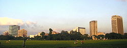


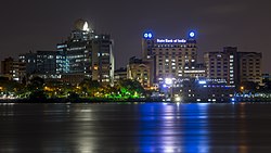


Kolkata is located in the eastern part of India. It has spread linearly along the banks of Hooghly River. The Kolkata Municipal Corporation has an area of 205 square kilometres.[1] The city is near sea level, with the average elevation being 17 feet.[2] The whole area is in the Ganges Delta which starts within 100 km south to the city. Most of the city was originally marshy wetlands, remnants of which can still be found especially towards the eastern parts of the city.
Geology
Indo-Gangetic Plain, the soil and water are predominantly alluvial in origin. Kolkata is located over the "Bengal basin", a pericratonic tertiary basin.[3] Bengal basin comprises three structural unit: shelf or platform in the west; central hinge or shelf/slope break; and deep basinal part in the east and southeast. Kolkata is located atop the western part of the hinge zone which is about Template:Convert wide at a depth of about Template:Convert below the surface.[3] The shelf and hinge zones have many faults, among them some are active. Total thickness of sediment below the Kolkata is nearly Template:Convert above the crystalline basement; of these the top Template:Convert is quaternary, followed by Template:Convert of tertiary sediments, Template:Convert trap wash of cretaceous trap and Template:Convert permian-carboniferous Gondwana rocks.[3] The quaternary sediments consist of clay, silt, and several grades of sand and gravel. These sediments are sandwiched between two clay beds: the lower one at a depth of Template:Convert; the upper one Template:Convert in thickness.[4] According to the Bureau of Indian Standards, on a scale ranging from I to V in order of increasing susceptibility to earthquakes, the city lies inside seismic zone III.[5]
City geography


Spread roughly north–south along the east bank of the Hooghly River, Kolkata sits within the lower Ganges Delta of eastern India; the city's elevation is Template:Convert.[6]
Urban structure

The Kolkata metropolitan area is spread over Template:Convert[7]Template:Rp and comprises 4 municipal corporations (Kolkata Municipal Corporation, Bidhannagar Municipal Corporation, Howrah Municipal Corporation and Chandernagore Municipal Corporation), 37 local municipalities (Bally Municipality is merged with Howrah Municipal Corporation and Rajarhat-Gopalpur Municipality is merged with Bidhannagar Municipal Corporation, so total number of municipalities becomes 37 from 39) and 24 panchayat samitis.Template:See also The urban agglomeration encompassed 72 cities and 527 towns and villages, Template:As of.[8] Suburban areas in the Kolkata metropolitan area incorporate parts of the following districts: Kolkata, North 24 Parganas, South 24 Parganas, Howrah, Hooghly and Nadia.[9]Template:Rp Kolkata, which is under the jurisdiction of the Kolkata Municipal Corporation (KMC), has an area of Template:Convert.[10] The east–west dimension of the city is comparatively narrow, stretching from the Hooghly River in the west to roughly the Eastern Metropolitan Bypass in the east—a span of Template:Convert.[11] The north–south distance is greater, and its axis is used to section the city into North, Central and South Kolkata. East Kolkata is also a section.


North Kolkata
North Kolkata is the oldest part of the city. Characterised by 19th-century architecture, dilapidated buildings, overpopulated slums, crowded bazaars, and narrow alleyways, it includes areas such as Shyambazar, Hatibagan, Maniktala, Kankurgachi, Rajabazar, Shobhabazar, Shyampukur, Tala, Sonagachi, Kumortuli, Bagbazar, Jorabagan, Burrabazar, Jorasanko, Phoolbagan, Ultadanga, Chitpur, Pathuriaghata, Cossipore, Belgachia and Sinthee.[12]Template:Rp
Central Kolkata
Central Kolkata hosts the central business district. It contains B. B. D. Bagh, formerly known as Dalhousie Square, and the Esplanade on its east; Strand Road is on its west.[13] The West Bengal Secretariat, General Post Office, Reserve Bank of India, High Court, Lalbazar Police Headquarters, and several other government and private offices are located there. Another business hub is the area south of Park Street, which comprises thoroughfares such as Chowringhee, Camac Street, Wood Street, Loudon Street, Shakespeare Sarani and A. J. C. Bose Road.[14] The Maidan is a large open field in the heart of the city that has been called the "lungs of Kolkata"[15] and accommodates sporting events and public meetings.[16] The Victoria Memorial and Kolkata Race Course are located at the southern end of the Maidan. Other important areas of Central Kolkata are Park Circus, Sealdah, College Street, Burrabazar, Bowbazar, Taltala, Janbazar, Entally, Chandni Chowk, Lalbazar, Chowringhee, Dharmatala, Rabindra Sadan, Tiretti Bazaar, Bow Barracks, Babughat, Princep Ghat and Hastings. Another important park is Millennium Park on Strand Road, beside the Hooghly River. Fort William, on the western part of the city (besides Maidan), houses the headquarters of the Eastern Command of the Indian Army.[17]
South Kolkata
Template:Unreferenced section South Kolkata developed mainly after India gained independence in the year 1947. It includes upscale neighbourhoods such as Ballygunge, Alipore, New Alipore, Lansdowne, Bhawanipore, Kalighat, Gariahat, Charu Market, Chetla, Jodhpur Park, Lake Gardens, South City, Jadavpur, Dhakuria and Tollygunge.[18]
Other developed areas of South Kolkata include Khidirpur, Ekbalpur, Taratala, Behala, Golf Green, Katju Nagar, Poddar Nagar, Bikramgarh, Bijoygarh, Regent Estate, Ranikuthi, Regent Park, Netaji Nagar, Bansdroni, Kudghat, Naktala, Garia, Raipur, Brahmapur, Baghajatin, Kalikapur, Kasba, Haltu, Nandi Bagan, Santoshpur, Garfa, Haridevpur, Sarsuna, Barisha, Parnasree Pally, Watgunge, Bartala, BNR Colony, Metiabruz, Rajabagan, Garden Reach and Badartala.
East Kolkata
East Kolkata is largely composed of newly developed areas like Beliaghata, Topsia, Picnic Garden, Tangra, Gobra, Kustia, Tiljala, Anandapur, East Kolkata Twp, Panchasayar, Madurdaha, Nayabad, Kalikapur, Purbalok, Mukundapur, Ajoy Nagar, Hiland Park, Chak Garia, Patuli, Budherhat, Nayabad and New Garia. Outlying developing areas include Dhapa, Uttar Panchannagram, Chowbaga, Bantala and VIP Nagar. In the pace of rapid urbanization and growing demand for housing and commercial spaces, the New Town, Kolkata was created in the eastern outskirts of Kolkata to serve the dual purposes of establishing new business centre to reduce the mounting pressure on the existing Central Business Districts (CBD) and increasing housing stock supply by creating new residential units.
Howrah and Hooghly (Urban)
Technically Howrah and the urban part of Hooghly all have individual identity alongside they are the part of Kolkata Metropolis. Likewise Howrah city is a twin city of Kolkata city. Nabanna, Santragachi, Belur, Bally, Uttarpara, Konnogar, Rishra, Serampore, Bhadeswar, Chinsurah, Hooghly, Chandannagor and Bandel all cities under Kolkata Metropolitan Area, having own fragrance of history, culture. This area is called "Little Europe Of India". All areas are well connected with the city centre.
Climate
Template:Main Kolkata has a Tropical wet-and-dry climate, with summer monsoons. The annual mean temperature is 26.8 °C (80 °F); monthly mean temperatures range from 19 °C to 30 °C (67 °F to 86 °F) and maximum temperatures can often exceed 40 °C (104 °F) during May–June. Winter tends to last from December to early-February, with the lowest temperatures hovering in the 12 °C — 14 °C range during December and January. The highest recorded temperature is 43 °C (111 °F) and the lowest is 5 °C (41 °F).[19]
Monsoon is the most notable phenomenon in the climate of the city. Maximum rainfall occurs during the monsoon in August (306 mm) and the average annual total is 1,582 mm. Early morning mists and evening smog occur often due to temperature inversions. Summer is dominated by strong southwesterly monsoon winds. The city's total duration of sunshine is 2,528 hours per annum, with the maximum insolation occurring in March.[20] Often during early summer, spells of thunderstorm and heavy rains lashes the city, bringing some relief from the heat and intolerable humidity. These thunderstorms are locally known as Kalbaishakhi (Nor-wester). According to a United Nations Development Programme report, its wind and cyclone zone is "very high damage risk".[5]
Notes
- ↑ Kolkata Municipal Corporation.
- ↑ Calcuttaweb site. Retrieved 18 March 2006.
- ↑ 3.0 3.1 3.2 Template:Cite conference
- ↑ Situation analysis. Production systems and natural resources use in PU Kolkata.
- ↑ 5.0 5.1 Hazard profiles of Indian districts. UNDP.
- ↑ PIA01844: space radar image of Calcutta, West Bengal, India. NASA(15 April 1999).
- ↑ Introducing KMA. Kolkata Metropolitan Development Authority.
- ↑ 007 Kolkata (India). World Association of the Major Metropolises.
- ↑ Kolkata—an outline{{#if:|, {{{last}}}}. Town and Country Planning Organisation, Ministry of Urban Development, Government of India(2008)
- ↑ Official Website of Kolkata Municipal Corporation. www.kmcgov.in.
- ↑ Template:Cite map
- ↑ Trends in land prices in Kolkata{{#if:|, {{{last}}}}. Town and Country Planning Organisation, Ministry of Urban Development, Government of India(2008)
- ↑ Kolkata heritage. Government of West Bengal.
- ↑ BSNL may take two weeks to be back online. The Times of India(9 July 2009).
- ↑ In city's teeming heart, a place to gaze and graze. The New York Times(27 January 2011).
- ↑ Maidan marauders. The Telegraph(21 February 2010).
- ↑ Eastern Command. Indian Army.
- ↑ Globalizing cities: a new spatial order?{{#if:Chakravorty|, Chakravorty}. Blackwell Publishing(2000). ISBN 978-0-631-21290-4
- ↑ Weatherbase entry for Kolkata
- ↑ GAIA article