
Template:More citations needed
| Kothamangalam | |
|---|---|
|
[[File:|250x250px|frameless|center]] | |
| Settlement type | Municipality[1] |
| Country | India |
| State | |
| District | |
| Subdivision | |

Kothamangalam (Template:IPA) is a municipality[2] at the foot of the Western Ghats in the Ernakulam district of Kerala, India. It is located Template:Convert east of the district collectorate in Thrikkakara and about Template:Convert north of the state capital Thiruvananthapuram. As per the 2011 Indian census, Kothamangalam has a population of 38,837 people, and a population density of Template:Convert.
Geography
Kothamangalam is situated in the eastern part of the Ernakulam district. According to the division of the geographical regions of Kerala, Kothamangalam is in a mid-land region.[3] The general topography is hilly.
The Periyar, the largest river in Kerala, flows through the taluk. There are dams built across the Periyar at Edamalayar, Lower Periyar, and Bhoothathankettu for hydroelectricity generation and irrigation purposes. The current Kothamangalam region was historically known as Malakhachira (Template:Lang).[4][5] Kothamangalamar, a small river which flows through the town joins Kaliyar and Thodupuzhayar to form the Muvattupuzhayar, which is the second largest river in Ernakulam.
Demographics
Template:Bar box According to the 2011 Census of India, Kothamangalam had a total population of 38,837,[6] 19,029 being males and 19,808 females. There are 30,067 households in the Kothamangalam municipality.[7] The literacy rate of Kothamangalam Agglomeration is 95.24%, in comparison to the national urban average literacy in India of 85%. The literacy rate of males and females were 97.04% and 93.48% respectively. There were 98,398 who were literate, of which 49,412 were males and the remaining 48,986 were females.
Administration
The Kothamangalam municipality was formed in 1978 and is the headquarters of the taluk. The municipality has an area of Template:Cvt and is divided into 31 electoral wards. Elections to the local self bodies are held once every five years. From the elected municipal councilors, a chairman and vice-chairman are elected.
Kothamangalam is part of the Idukki Lok Sabha constituency;[8] until 2009, it was part of Muvattupuzha Lok Sabha constituency. Kothamangalam is also represented in the Kerala Legislative Assembly as a constituency. The panchayats in Kothamangalam Taluk are Nellikuzhi, Kottapady, Pindimana, Varapetty, Pallarimangalam, Pothanikkad, Paingottoor, Kavalangad, Keerampara, Vadattupara, Kuttampuzha, and Edamalakkudy.
Education
Religious pilgrimages

Churches
- Marth Mariyam Jacobite Syrian Sonoroo Cathedral Great Church
- Mar Thoma Jacobite Syrian Orthadox Cheriapally
Temples
Road
- Kochi - Kolenchery - Muvattupuzha (53 Km)
- Angamaly - Kalady - Perumbavoor (34 Km)
- Aluva - Perumbavoor (35 Km)
- Munnar - Anachal - Adimali - Neriamangalam - Oonukal (73 Km)
- Kottayam - Ettumanoor - Kuravilangad - Muvattupuzha (68 Km)
- Thodupuzha - Kumaramangalam - Paingottor (29 Km)
- Vagamon - Thodupuzha - Muvattupuzha (69 Km)
Gallery
-
 Mar Thoma Jacobite Syrian Cheriapally, is a Jacobite Church Situated In The Centre Of The City Of Kothamangalam
 -
 Marth Mariyam Jacobite Syrian Sonoroo Cathedral Great Church, is a Jacobite Church Situated In The Centre Of The City Of Kothamangalam
 -
 Rainy Evening in the city Of Kothamangalam In the month of June
 -
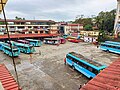 Aerial view of kothamangalam Private Bus Stand On A Evening
 -
 Bhoothathankettu Dam On A Rainy Evening
 -
 St. George's Cathedral, is a Catholic Church In The Centre Of Kothamangalam City
 -
 Revenue Tower Of Kothamangalam Near the Private Bus Stand
 -
 Aerial view of kothamangalam Cheriya palli


Villages
- Chathamattam
- Nellikuzhi
- Keerampara
- Kottappady
- Kuttampuzha
- Neriamangalam
- Pindimana
- Pothanikkad
- Thrikkariyoor
- Varappetty
- Venduvazhy
References
- ↑ Grama Panchayaths.
- ↑ Grama Panchayaths.
- ↑ Eranakulam. Kerala Government Statistics
- ↑ Journal of South Indian History{{#if:|, {{{last}}}}. Publication Division, University of Calicut(2005)
- ↑ In Quest of Kerala: Geography, places of interest, political history, social history, literature{{#if:|, {{{last}}}}. Accent Publications(1974)
- ↑ [. Census2011.co.in. Retrieved on 2015-04-19.
- ↑ Kothamangalam Block. Ernakulam.nic.in. Retrieved on 2015-04-19.
- ↑ Assembly Constituencies – Corresponding Districts and Parliamentary Constituencies. Retrieved 2008-10-19.
External links
Template:Kerala Template:Municipalities of Kerala Template:Ernakulam district Template:Northern Travancore