
| Chaglagam | |
|---|---|
|
[[File:|250x250px|frameless|center]] | |
| Settlement type | Village |
| Country | India |
| State | |
| District | |
| Subdivision | |
Chaglagam is a village and the headquarters of an eponymous circle in the Anjaw district in the north-eastern state of Arunachal Pradesh, India.[1]
Chaglagam is situated on the bank of the Chaglagam River, which is a headwater of the Delei River, which in turn is a tributary of the Lohit River joining it near Hayuliang.[2] Hayuliang is the nearest town to Chaglagam and the headquarters of the subdivision of which Chaglagam is a part.
The Chaglagam Circle is a border region of Arunachal Pradesh, with the Zayul County of China's Tibet Autonomous Region across the border. It had a population of 1,681 people, distributed in 18 villages, as per the 2011 census.[3]
Geography
Chinese incursions
In August 2013, China's People's Liberation Army troops had invaded 20 to 30 km inside the Indian territory and stayed there for 4 days before being sent back by India's Indo-Tibetan Border Police (ITBF).[4]
Transportation
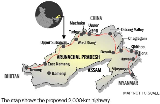
Chaglagam is located on the Template:Convert proposed Mago-Thingbu to Vijaynagar Arunachal Pradesh Frontier Highway along the McMahon Line,[5][6][7][8] alignment map of which can be seen here and here.[9]

Demographics
As per the 2011 Census of India, it has 192 residents across 29 households. 155 are male, and 37 are female.[1]
References
- ↑ 1.0 1.1 2011 Census of India: Chaglagam
- ↑ Map of Anjaw, Anjaw District website, retrieved 5 July 2021.
- ↑ Anjaw District Census Handbook, Part A, Census of India, 2012, p. 20.
- ↑ Top officials to meet to expedite road building along China border. NDTV India.
- ↑ Top officials to meet to expedite road building along China border. timesofindia.indiatimes.com.
- ↑ Narendra Modi government to provide funds for restoration of damaged highways.
- ↑ Indian Government Plans Highway Along Disputed China Border. thediplomat.com.
- ↑ Govt planning road along McMohan line in Arunachal Pradesh: Kiren Rijiju. Live Mint.
- ↑ China warns India against paving road in Arunachal. tribuneindia.com.
Template:Arunachal Pradesh Template:Minority Concentrated Districts in India Template:Geographic location