
Template:Distinguish Template:Use British English
Dibang Valley district (Template:IPAc-en Template:Respell) is a district of the Indian state of Arunachal Pradesh[1] named after the Dibang River[2] or the Talon as the Mishmis call it. It is the least populated district in India and has an area of Template:Convert.[3]
History
In June 1980, Dibang Valley district was created out of part of Lohit district.[4] On 16 December 2001, Dibang Valley district was bifurcated into Dibang Valley district and Lower Dibang Valley district.[4]
Geography

The Dibang River originates in the mountains of Arunachal Pradesh and flows through the length of the valley which is named after it. The Dibang has multiple tributaries and only once it debouches into the plains is it called by its name. Some of the major rivers of Dibang Valley District are the Ahui, Emra, Mathun, Dri, Tangon, Ithun, and Ange. The capital of this district, Anini, is the northernmost district capital in Northeast India. This district contains the northernmost point of Northeast India.Template:Citation needed
Transport
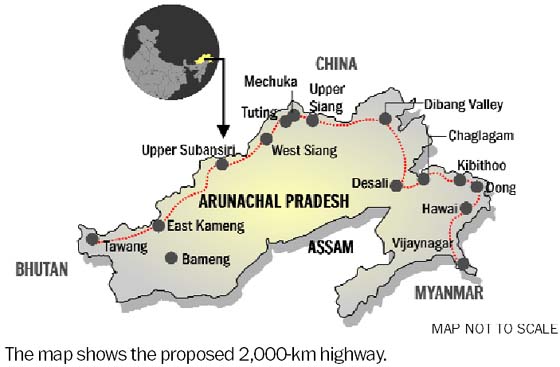
The Template:Convert proposed Mago-Thingbu to Vijaynagar Arunachal Pradesh Frontier Highway along the McMahon Line,[5][6][7][8] (will intersect with the proposed East-West Industrial Corridor Highway) will pass through this district, alignment map of which can be seen here and here.[9]

Divisions
There is only one Arunachal Pradesh Legislative Assembly constituency in this district- the Anini constituency. It is part of Arunachal East Lok Sabha constituency.[10]
Demographics
Template:Historical populationsAccording to the 2011 census, Dibang Valley district has a population of 7,948,[3] roughly equal to the nation of Nauru.[11] This gives it a ranking of 640th in India (out of a total of 640).[3] The district has a population density of Template:Convert. With this, it is also the most sparsely populated district in India.[3] Its population growth rate over the decade 2001–2011 was 9.3%.[3] Dibang Valley has a sex ratio of 808 females for every 1000 males,[3] and a literacy rate of 64.8%.[3]
The major population of this district consists of Mishmi (Idu).
The Mishmis have a story narrating the first journeys undertaken in course of migration. The story conveys the names and location of the Cheethu-Huluni or the twelve rivers that the Mishmi (Idu) people came over in the region and settled around. The first accounts of the Mishmi (Idus) are found in the narrations given by the neighboring Ahoms. The Mishmis inhabited the deep jungles of what is now the Dibang valley.
Religion
About 40% of the district's population follows Hinduism.[12] The Mishmi(Idu) people here believes that Rukmini-Chief Consort of Lord Krishna belonged to their tribe.[13] The plays and dances on 'Rukmini haran' are common. There is a legend that
Lord Krishna asked the Mishmi people to cut their hair as a form of punishment for not allowing him to marry Rukmini. Due to this Idu-Mishmi people are also called "chulikata" (chuli-hair, kata- cut).[14]
Languages
Languages spoken include Idu Mishmi with approximately 25,000 speakers, written in both Latin and Devanagric scripts.
Flora and fauna
The district is rich in wildlife. Rare mammals such as Mishmi takin, red goral and Gongshan muntjac occur, while among birds there is the rare Sclater's monal.[15] A flying squirrel new to science was discovered from this district in the 2000s. It has been named as Mishmi giant flying squirrel, Petaurista mishmiensis.[16]
In 1991, Dibang Valley district became home to the Dibang Wildlife Sanctuary, which has an area of Template:Convert.[17]
Map

References
- ↑ National Portal of India : Know India : Districts of India. India.gov.in.
- ↑ History : Lower Dibang Valley. Roing.nic.in (16 December 2001).
- ↑ 3.0 3.1 3.2 3.3 3.4 3.5 3.6 Cite error: Invalid
<ref>tag; no text was provided for refs nameddistrictcensus - ↑ 4.0 4.1 Districts of India, Law, Gwillim(25 September 2011). Retrieved 2011-10-11.
- ↑ Top officials to meet to expedite road building along China border. Retrieved 27 October 2014.
- ↑ Narendra Modi government to provide funds for restoration of damaged highways. www.dnaindia.com. Retrieved 27 October 2014.
- ↑ Indian Government Plans Highway Along Disputed China Border. thediplomat.com. Retrieved 27 October 2014.
- ↑ Govt planning road along McMohan line in Arunachal Pradesh: Kiren Rijiju. Live Mint. Retrieved 2014-10-26.
- ↑ China warns India against paving road in Arunachal. tribuneindia.com. Retrieved 2014-10-26.
- ↑ Assembly Constituencies allocation w.r.t District and Parliamentary Constituencies. Chief Electoral Officer, Arunachal Pradesh website. Retrieved 21 March 2011.
- ↑ Country Comparison:Population. Retrieved 2011-10-01.
- ↑ Cite error: Invalid
<ref>tag; no text was provided for refs namedCensus - ↑ A twist in the myth: Rukmini’s vague Arunachal connection. Retrieved 13 March 2020.
- ↑ Fact Check: Did Rukmini come from Arunachal Pradesh? Here is what we know. The Indian Express(29 March 2018). Retrieved 13 March 2020.
- ↑ Choudhury, Anwaruddin(2008) Survey of mammals and birds in Dihang-Dibang biosphere reserve, Arunachal Pradesh. Final report to Ministry of Environment & Forests, Government of India. The Rhino Foundation for nature in NE India, Guwahati, India. 70pp.
- ↑ Choudhury, Anwaruddin (2009).One more new flying squirrel of the genus Petaurista Link, 1795 from Arunachal Pradesh in north-east India. The Newsletter and Journal of the RhinoFoundation for nat. in NE India 8: 26–34, plates.
- ↑ Protected areas: Arunachal Pradesh. Retrieved 25 September 2011.