


File:2011-Sikkim earthquake Shakemap.jpg

Size of this preview: 512 × 600 pixels. Other resolutions: 205 × 240 pixels | 612 × 717 pixels.
Original file (612 × 717 pixels, file size: 131 KB, MIME type: image/jpeg)

Summary
| Description |
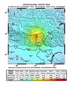
English: USGS ShakeMap of the magnitude 6.8 Sikkim earthquake, Sep. 2011.
Español: Un fuerte sismo de 6,9 grados en la escala sismológica de momento remeció la zona montañosa norte de la India, específicamente la región de Sikkim donde se reportan siete derrumbes de tierra. |
| Date | |
| Source | https://earthquake.usgs.gov/earthquakes/shakemap/global/shake/c0005wg6/ |
| Author | United States Geological Survey |
Licensing

|
This image is in the public domain in the United States because it only contains materials that originally came from the United States Geological Survey, an agency of the United States Department of the Interior. For more information, see the official USGS copyright policy.
|
 |
File history
Click on a date/time to view the file as it appeared at that time.
| Date/Time | Thumbnail | Dimensions | User | Comment | |
|---|---|---|---|---|---|
| current | 08:01, 19 September 2011 | | 612 × 717 (131 KB) | wikimediacommons>Haffman | update |
File usage
The following page uses this file:
