


File:Carte Empire-Khmer.png
No higher resolution available.
Carte_Empire-Khmer.png (435 × 445 pixels, file size: 33 KB, MIME type: image/png)

Summary
| Description |
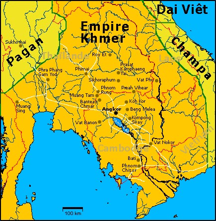
Carte de l'empire khmer à son apogée, au XIIe siècle sous Jayavarman VII avec les principaux sites visibles aujourd'hui. Illustration personnelle libre de droits sur base d'une carte OMC. English: French Map of Khmer Empire under Jayavarman VII. |
| Date | 8 August 2005 (original upload date) |
| Source | Transferred from fr.wikipedia to Commons. |
| Author | Lozère at French Wikipedia |
Licensing

|
I, the copyright holder of this work, release this work into the public domain. This applies worldwide. In some countries this may not be legally possible; if so: I grant anyone the right to use this work for any purpose, without any conditions, unless such conditions are required by law. |
Original upload log
The original description page was here. All following user names refer to fr.wikipedia.

- 2006-04-15 20:33 Lozère 435×445×8 (33591 bytes) Avec les routes/With roads
- 2005-08-28 17:08 Lozère 435×445×8 (31287 bytes) Quelques ajouts
- 2005-08-09 19:51 Lozère 435×445×8 (44624 bytes) Etats actuels
- 2005-08-09 19:48 Lozère 435×445×8 (44246 bytes)
- 2005-08-08 15:02 Lozère 435×445×8 (29364 bytes) +Pagan
- 2005-08-08 14:31 Lozère 435×445×8 (41966 bytes) Carte de l'empire khmer à son apogée, au XIIe siècle sous Jayavarman VII avec les principaux sites visibles aujourd'hui. Illustration personnelle libre de droits sur base d'une carte OMC.
File history
Click on a date/time to view the file as it appeared at that time.
| Date/Time | Thumbnail | Dimensions | User | Comment | |
|---|---|---|---|---|---|
| current | 18:47, 15 March 2007 | | 435 × 445 (33 KB) | wikimediacommons>Lozère | {{Information |Description=Carte de l'empire khmer à son apogée, au XIIe siècle sous Jayavarman VII avec les principaux sites visibles aujourd'hui. English: Map of Khmer Empire under Jayavarman VII. |Source=Own work, on the basis of an OMC map. |Date=1 |
File usage
There are no pages that use this file.
