


File:Chola Empire map2.png
No higher resolution available.
Chola_Empire_map2.png (466 × 333 pixels, file size: 85 KB, MIME type: image/png)

Summary
| Description |
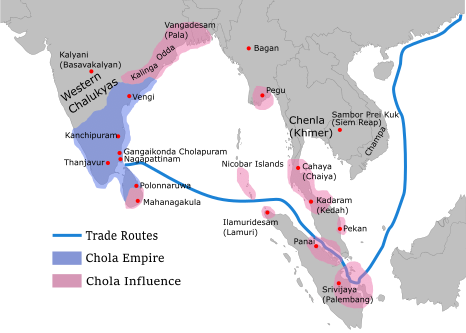
English: Map showing the extent of the Chola empire during 10 – 11th century according to http://cw.routledge.com/textbooks/9780415485432/15.asp"THE CŌḶAS" by k. a. nilakanta sastri The file has changed from the original. The correction about the Chola influence in Malay areas is based on https://archive.org/details/earlykingdomsofi0000muno/page/118/mode/2up The influence added the area of Lamuri based on Tanjore inscription. Andaman is deleted leaving only Nicobar (information on Tanjore inscription). |
| Date | |
| Source | https://upload.wikimedia.org/wikipedia/commons/archive/c/cf/20110528043623%21Rajendra_map_new.svg |
| Author | Gregors |

Licensing


This file is licensed under the Creative Commons Attribution-Share Alike 3.0 Unported license.
- You are free:
- to share – to copy, distribute and transmit the work
- to remix – to adapt the work
- Under the following conditions:
- attribution – You must give appropriate credit, provide a link to the license, and indicate if changes were made. You may do so in any reasonable manner, but not in any way that suggests the licensor endorses you or your use.
- share alike – If you remix, transform, or build upon the material, you must distribute your contributions under the same or compatible license as the original.
File history
Click on a date/time to view the file as it appeared at that time.
| Date/Time | Thumbnail | Dimensions | User | Comment | |
|---|---|---|---|---|---|
| current | 23:08, 19 May 2024 | No thumbnail | 466 × 333 (85 KB) | wikimediacommons>SKAG123 | Reverted to version as of 01:49, 5 December 2023 (UTC) |
File usage
The following page uses this file:
