
.png&action=edit§ion=new)

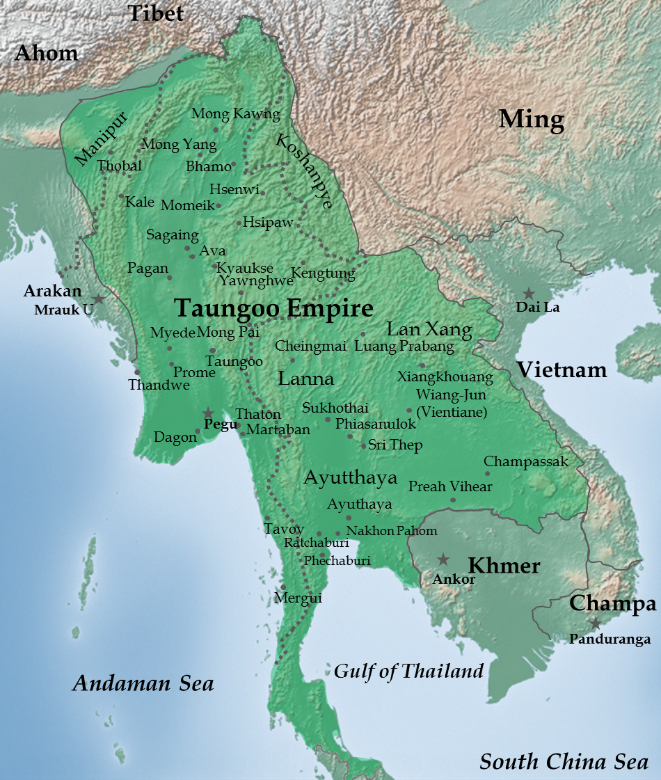
File:Map of Taungoo Empire (1580).png
Size of this preview: 508 × 599 pixels. Other resolutions: 203 × 240 pixels | 407 × 480 pixels | 950 × 1,121 pixels.

Original file (950 × 1,121 pixels, file size: 1.5 MB, MIME type: image/png)
.png)

|
This historical map image could be re-created using vector graphics as a SVG file. This has several advantages; see Commons:Media for cleanup for more information. If a SVG form of this image is available, please upload it and afterwards replace this template with
{{vector version available|new image name}}.It is recommended to name the SVG file “Map of Taungoo Empire (1580).svg”—then the template Vector version available (or Vva) does not need the new image name parameter. |
Summary
| Description |
English: Taungoo Empire at its highest extent during the reign of King Bayinnaung (1551-1581) |
| Date | |
| Source | Own work. Background map is taken from www.naturalearthdata.com (public domain: Terms of Use). |
| Author | Soewinhan |
References

Refer to the
- timemap from University of California, Berkeley archive copy at the Wayback Machine for the extent of Ayutthaya, Lang Xang and Lanna before Bayinnaung's conquest.
- Victor B. Lieberman (2003) Strange parallels: Southeast Asia in global context, c 800-1830, Volume 1, pp. 152 ISBN: 0521804965. for the extent of Taungoo Empire as of 1580.
- File:Map of Toungoo Kingdom 1572.jpg and File:Map-of-southeast-asia 900 CE.png for geographic names.
- Baker, Chris. Phongpaichit, Pasuk. A History of Ayutthaya: Siam in the Early Modern World.
Notes
- The borders at that times were not demarcated. As stated in Berkeley timemap: The level of details present in some boundaries should not be interpreted as a result of a precise, detailed understanding of the borders of states during this period.
Licensing
I, the copyright holder of this work, hereby publish it under the following license:


This file is licensed under the Creative Commons Attribution-Share Alike 3.0 Unported license.
- You are free:
- to share – to copy, distribute and transmit the work
- to remix – to adapt the work
- Under the following conditions:
- attribution – You must give appropriate credit, provide a link to the license, and indicate if changes were made. You may do so in any reasonable manner, but not in any way that suggests the licensor endorses you or your use.
- share alike – If you remix, transform, or build upon the material, you must distribute your contributions under the same or compatible license as the original.
File history
Click on a date/time to view the file as it appeared at that time.
| Date/Time | Thumbnail | Dimensions | User | Comment | |
|---|---|---|---|---|---|
| current | 02:28, 14 July 2023 | | 950 × 1,121 (1.5 MB) | wikimediacommons>Yourlocallordandsavior | Reverted to version as of 06:37, 14 February 2023 (UTC) |
File usage
The following page uses this file:
.png)