


File:Uttar Pradesh locator map.svg

Size of this PNG preview of this SVG file: 615 × 599 pixels. Other resolutions: 246 × 240 pixels | 492 × 480 pixels | 788 × 768 pixels | 1,051 × 1,024 pixels | 2,101 × 2,048 pixels | 909 × 886 pixels.



Original file (SVG file, nominally 909 × 886 pixels, file size: 838 KB)

Summary
| Description |
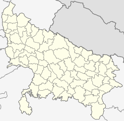
English: This map has been created by Faiz Haider, it is based on Map of Uttar Pradesh on National Portal of India. Equirectangular projection. Geographic limits of the map: top=31.00, bottom=23.50, left=76.60, right=85.00. |
| Date | 10 February 2009 (original upload date) |
| Source | Transferred from en.wikipedia to Commons by Hanhil using CommonsHelper. |
| Author | Faizhaider at English Wikipedia |
Licensing

|
This work has been released into the public domain by its author, Faizhaider at English Wikipedia. This applies worldwide. In some countries this may not be legally possible; if so: Faizhaider grants anyone the right to use this work for any purpose, without any conditions, unless such conditions are required by law. |
Original upload log
The original description page was here. All following user names refer to en.wikipedia.

- 2009-02-10 08:49 Faizhaider 2400×2515× (140024 bytes) This map has been created by [[User:Faizhaider|me]], it is based on [http://india.gov.in/maps/up.php Map of Uttar Pradesh on National Portal of India].
File history
Click on a date/time to view the file as it appeared at that time.
| Date/Time | Thumbnail | Dimensions | User | Comment | |
|---|---|---|---|---|---|
| current | 03:11, 8 January 2021 | | 909 × 886 (838 KB) | wikimediacommons>C1MM | Updated districts, made more accurate boundaries |
File usage
There are no pages that use this file.
